Satellite Imagery
- NASA's
Tutorial
is a friendly introduction to satellite imagery (gentle enough for children)
- LandSat
- LandSat is the name of a series of US imagery satellites. The most
commonly encountered data is from LandSat 4/5 or LandSat 7 (the latest).
- the data was collected with US taxpayer money, so the raw data is in
the public domain
- however, you generally still have to pay someone to process the
images (color-correct, merge, and improve georegistration) which
typically costs $400 to $2000 per "scene"
- each scene (image) is around 80 km on an edge
- see Terrainmap.com article on
LandSat 7 Satellite
Imagery
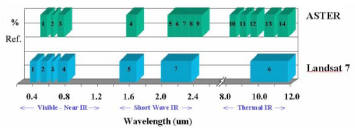
- each of the LandSat raw images has 8 bands, a lot more than just
RGB:
- "LandSat bands 3, 2, and 1 are the red, green, and blue
reflected light. Assigning bands 3,2,1 to color channels red, green,
and blue produces a "natural color composite" very similar to what
you might see if you were flying over an area in an airplane."
- LandSat7 bands:
- Band 1 0.45-0.52 Blue-Green
- Band 2 0.53-0.61 Green (often mapped to Blue)
- Band 3 0.63-0.69 Red (often mapped to Green)
- Band 4 0.75-0.90 Near IR (often mapped to Red)
- Band 5 1.55-1.75 Mid-IR
- Band 6 10.4-12.5 Thermal IR
- Band 7 2.09-2.35 Short Wave IR
- Band 8 0.52-0.90 Panchromatic
- if you need to determine what LandSat scene is at a particular
location, there are
Shapefiles available from the GLCF: WRS2 is the "world reference
system" used for LandSat 5-7
- ASTER
-
 launched
by NASA with international partners, since 2000 ASTER provides free or
low-cost imagery (as well as elevation!)
- the 14 bands vary from 15m to 90m
resolution, each scene is 60 x 60 km
- note that
compared to LandSat7, there are no bands
which map well onto RGB visible light, though
an article on
terrainmap.com
says that reasonable results may still be possible
- MODIS
 [site down on 05.08.12]
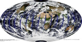
- The Moderate Resolution Imaging Spectroradiometer (MODIS)
instrument, was launched on the Terra platform December 1999; the second
instrument on the Aqua platform May 2002
- it is well-designed to capture visible light at moderate spatial
resolution (250m –1km), to detect a large ranger of phenomena, and has
near daily global coverage
- some data is available online, see Free
Sources of Imagery
- IKONOS
-
Space Imaging IKONOS
satellite is the world's first commercial 1-meter remote sensing
satellite
- reportedly, "Space Imaging has made available for free download a
sizable database of satellite imagery for the United States and for
International locations"
- see
Commercial sources for how to buy IKONOS images, and the other
commercial imagery vendors
- Alex's Remote
Sensing Imagery Summary Table (ARSIST) was a list as of 2004 of the
status, capabilities and availability of data from the most important
satellite sources (around 30)
 launched
by NASA with international partners, since 2000 ASTER provides free or
low-cost imagery (as well as elevation!)
 [site down on 05.08.12]