Commercial Sources of Aerial/Satellite Imagery with Global Coverage
Vendors of imagery often appear and change; this is just a moving snapshot of
some of the more prominent firms including data providers and resellers.
Listed alphabetically:
- Astrium GEO-Information Services
- they own SPOT, which was/is an older French satellite data producer, typically $1500-6000 per image,
generally resold by other agencies
- SPOT image types: panchromatic and multi-spectral (3 bands: Red,
Green, Near-Infrared)
- the color bands are typically quite crude, e.g.. 4-5 bits for Red, 3-5
bits for Green
- DigitalGlobe
- operates satellites:
- QuickBird
(2001): 0.61 m panchromatic, 2.44 m truecolor
- WorldView-1
(2007): 0.50 m panchromatic
- WorldView-2
(2009): 0.46 m panchromatic, 1.85 m eight-band multispectral
- they don't sell imagery directly, but through a set of resellers
- a lot of the best high-resolution images have been licensed by
Google for exclusive (!) use in Google Earth / Maps, which
means nobody else can use them at full resolution
- their CitySphere product (2005-2010) had orthorectified 60 cm color imagery of 200 of
the largest cities worldwide
- GeoEye, formed in 2006 from the
combination of:
- Space Imaging Inc.
- based in Thornton, CO, founded in 1994, formed by Lockheed
- sell imagery from their IKONOS satellite with 1-meter B&W
and 4-meter color resolution with high positional accuracy
- ORBIMAGE Inc.
- operated a series of satellites called ORBVIEW
- one-meter panchromatic and four-meter multispectral imagery from
their
OrbView-3
satellite
-
Getmapping PLC / Bluesky Intl.
Ltd.
- Getmapping is a UK company which sells a great deal of UK aerial
imagery, although they have many international assets, including the USA
- Bluesky is a supplier of aerial photography both as Getmapping's
master reseller and as a company in its own right
Some Resellers
- i-cubed
- they used to have a Millennium Mosaic™ which covered the entire USA
at 15m color, from LandSat7 pan-merge, but this appears to have vanished
from their site
- they still sell/resell a whole range of
aerial and
satellite imagery
- LAND INFO
Satellite
- MapMart
- A major portal with many partners (including Microsoft), offering a large amount of
Aerial Photography with direct online searching, purchasing and
download.
- their USA coverage does not include Alaska or Hawai'i; some of their
pricing seems a little odd, particularly $50/quad to download
public-domain USGS DOQQ files.
- MDA Federal

 bought
EarthSat, which sells a seamless global, true color 15m LandSat mosaic,
GeoCover NaturalVue
2000
bought
EarthSat, which sells a seamless global, true color 15m LandSat mosaic,
GeoCover NaturalVue
2000- by doing color-correction and pan-merge with an giant set of LandSat
images from the year 2000, they have the highest resolution complete
globe available anywhere
- pricing is very reasonable, ranging from $50 (for a single 5x6
degree tile) to $20,000 for the whole dataset (single user, more for
publishing or broadcasting)
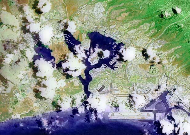
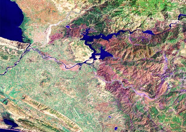
- Quality
issues: some areas are wonderful, others have strange colors. It is not
cloud-free, nor consistently true-color. See thumbnails to the right,
of Pearl Harbor and northern Albania.
- Satellite Imaging Corporation
(SIC)
- Resells and does services on data from QuickBird, IKONOS and SPOT.
- "TerraServer"
- Long ago, "TerraServer" was a joint project started by Microsoft Research, Aerial Images Inc.,
HP, Kodak and Sovinformsputnik, hosting USGS DOQ, SPIN-2 Russian satellite imagery, and other image
data sources. The site wass extremely slow, showing blurry, grainy monochrome
images, with very small areas of coverage.
- In 2003, it split into a commercial branch (TerraServer.com,
which resells other data today including DigitalGlobe), and a research
branch (Microsoft Research Maps)
There are also many vendors of national or regional data, which are listed
in the appropriate pages under Locations.