Urban Planning, Regional Planning, Land Use Planning
One of the most useful applications of visualization of the real world is in the planning process. Many of the first genuinely useful applications of the technology are in planning, for analysis, insight, and decision-making.
Forests - forest management and harvest planning - see forestry
Civil engineering and landscape architecture - see small terrain areas
 Regional
planning
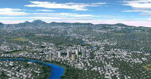
Regional
planning- example: Urban Sprawl: the Big Picture shows how 2D planning data from remote sensing has more profound visual impact on decision-makers when it is presented in 3D form
- CommunityViz is a suite of software for planning of cities and communities. In addition to its traditional GIS features and policy planning tools, it includes a component "SiteBuilder 3D" which provides a real-time 3D environment for creating and manipulating a virtual representation of a town and visually exploring different land-use alternatives. This is the cutting edge of planning.
- see the Commercial Software page for more about SiteBuilder 3D
Dr. Michael Flaxman at
 the
Harvard GSD
the
Harvard GSD
- For several years, Dr. Flaxman worked on projects which push the state of the art in visualization for planning purposes.
- Alternative Futures for Hangzhou, China - see the China page for more info
- his Studio Projects using visualization include projects in Israel and Germany
- research with visualization in the San Pedro River Basin Study - see more under Arizona on the U.S. Locations page
VisuLands (Portuguese site)
VisuLands (Swiss
site)
- 2003 - 2005
- A European project, working with different aspects of landscape visual quality to develop tools that increase the understanding of landscape changes, in order to assist planners and public alike to assess the outcomes of planning and management decisions.
- Consists of 7 partners from UK, Portugal, Switzerland, Sweden, France and Norway
- Each partner has a study area; e.g. in Portugal it is a case study of a protected area (Serra do Açor) in Portugal
The Open Planning Project (TOPP)
- A non-profit technology organization, dedicated to enhancing the ability of all citizens to engage in meaningful dialogue about their environment - the basis of sound planning.
- TOPP believes that information about public places is as important a public good as the physical places themselves; to this end, they advocate for and contribute to a free, distributed, and open geographic information infrastructure.
- They achieve this goal by supporting projects, including us (the VTP) and other important open-source enabling technologies such as the GeoServer Project