Evaluation of ESRI 3D Analyst
June 1999
Summary:
3D
Analyst
($2500) is a set of 3D extensions to ESRI's ArcView ($1000), the dominant GIS application.
Things that ArcView with 3DAnalyst can do:
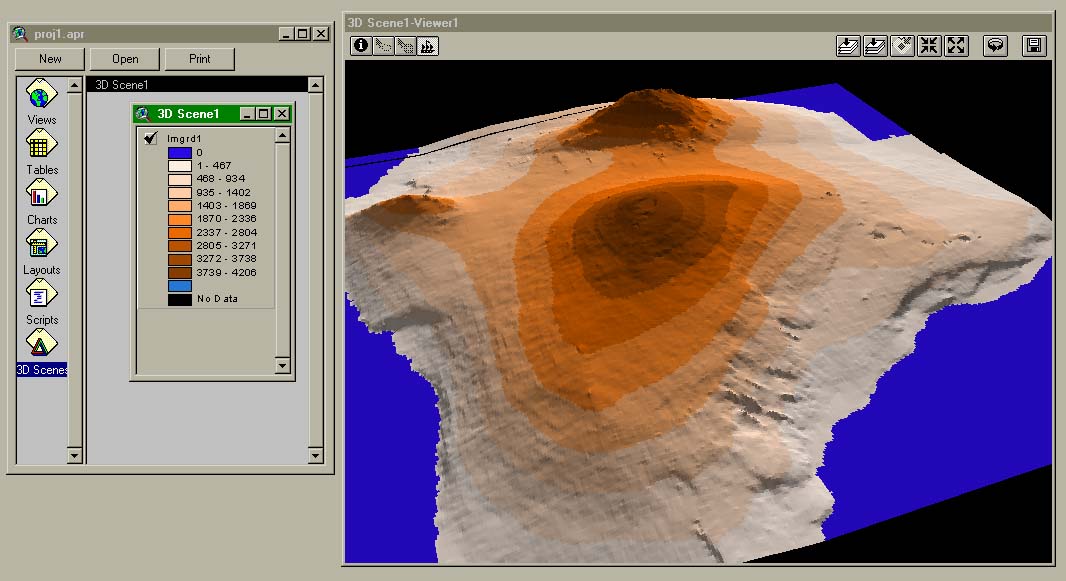
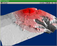
I was able to import a USGS 1-degree DEM and display it, flat-shaded with
color by elevation:
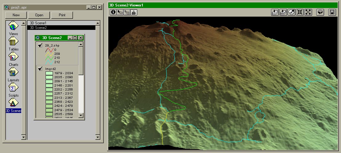
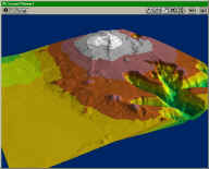
I was able to import a USGS 30-meter DEM and used a non-ESRI utility to
import a DLG-O road map. I could then drape the road vectors on the
terrain, and color them by attribute:
I was able to convert a regular grid to a TIN with no trouble.
However, the TIN was not only less attractive, but actually much slower to
render, defeating the purpose of generating an 'optimized' surface:
I'm still trying to drape an image on a terrain. It seems to be
supported, but there is no example showing how to apply an arbitrary bitmap
to an elevation (or vice-versa).
Things that ArcView/3DAnalyst does not do:
- can't convert DEM files from one projection to another (Arc/Info required)
- can't read DLG files directly
- can't join more than one DEM into a single surface
- can't read LULC (Arc/Info required)
- can't convert 2D road vectors into road polygons
- can't export 3D geometry
- no smooth shading - flat shading only, and no wireframes either
- doesn't report polygon counts
- doesn't run reliably - numerous hangs, crashes and inexplicable error
message
- doesn't pick objects reliably - even in their own examples, picking of 3D
objects was very broken
- doesn't let you navigate directly - the only metaphor allowed is "rotate
the scene"
Given all these problems and limitations, i wouldn't recommend ArcView/3D
Analyst for any virtual terrain work.
Detail Notes...
99.6.3
- filed Incidents #42133/#42153 with support at (909)793-3774 - they gave
the solution for the DEM files which is to rename the directory path
of the DEMs to not contain spaces. Ugh.
- they also confirmed that a non-ESRI utility at the BLM is the recommended
way to import DLG, and that only Arc/Info supports importing LULC via a
command called GIRAS2ARC
- made a 512x512 BMP file and tried to drape it on a 30m DEM file
- it wouldn't drape because the extents were different, but it wouldn't let
me change the extents of either data source either. Grrr.
99.6.2
- went through the 'quick start tutorial' - there was no example involving
regular gridded data
- the online help says "Standard USGS 7.5-minute, 1-degree, or any other
file in USGS DEM format is supported"
- tried to use the Import feature to bring in a 30-meter DEM file (30.dem)
- result: "GRID ERROR - Syntax error at or near symbol SPdem\30.dem",
nothing was imported
- tried a 1-degree DEM and 10-meter DEM, they wouldn't load either
- the import dialog doesn't list DLG, LULC, or any other USGS formats as
inputs!
- things discovered on the ARCVIEW-L
mailing list:
- a utility for
importing DLG exists, by converting them to Shape files
- ArcView doesn't support Datums
- found a discussion posting which implies that there may be no way
to import DEMs without using Arc/Info
- found a message from ESRI saying, as of Dec. 1997, there was no
way to import LULC into ArcView
- did succeed in importing a DLG file, using the non-ESRI utility
- unfortunately, it doesn't do more than one file at a time, and i have
at least 80 to convert
- it appears that all attribute information is lost in the conversion,
making the importation pretty much useless
- does 3D Analyst have any way to extrude the lines into road polygons?
appears the answer is no.