Cassandra & i spent two weeks gathering as much physical data on the
island as possible.
Tools used:
 |
Kodak DC260 digital camera with 48 MB of flash RAM |
 |
IBM Thinkpad 600 |
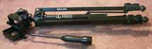 |
Tripod |
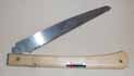 |
Folding saw |
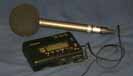 |
Sony DAT recorder |
Types of data gathered:
- Photographs of plant profiles, plant components, typical vegetation zones, scenic reference shots, roadsigns and cultural features. These were shot with the DC260 and downloaded to the Thinkpad via PCMCIA flash RAM as the end of the day. The saw was used to gather individual specimens of plants which normally grow too densely together in the wild. The tripod was used to maximize image stability, since image sharpness is vital for texture-map extraction.
- Vegetation coverage notes, hand-written while driving and entered into the laptop at the end of the day. The car's odometer was used to give location information for each data sample.
- Ambient sound samples, recorded in a few locations and times with the DAT recorder.
While this trip was very productive, there were some frustrations and potential to be much more effective in the future.
- The DC260 supports audio annotation of each image. While the feature works fine in the camera, the data did not come across via the flash RAM to the laptop, so those notes were lost.
- There was no way to integrate the road notes and the images. For instance, the notes may state "stopped to take photo of unidentified tree at mile 1.6" but without an indexing system it is difficult to track which photo corresponds to that note.
- Correlation of the written notes with a GIS will be difficult at best, since "mileage" is not a traditional GIS data type. It would be preferable to use a GPS system to give each data sample an absolute location.
- Getting the digital audio from the DAT to a computer may be a non-trivial task.
In the future, i envision an approach which will allow collection of audio, images and text description in a seamless, continuous, portable, georeferenced way. There are some technical challenges to be overcome, such as battery life, but within a year's time i hope to have at least some improved integration.
Another possibility is including video streams as a data type. This would be most useful if gathered as panoramic (surround) video, so that any detail not noticed at first could be extracted later by dynamically "walking" the video stream.